OlmoEarth v1.3 adds browser mapping with reusable satellite data
Ai2’s new release combines precomputed satellite features with a map explorer that requires no account. Annual coverage, local setup requirements and restrictions on permitted uses shape where it can be deployed.
In this article
Quick answers
Does the Explorer require an account?
Ai2 says the browser Explorer needs no sign-in. Hosted platform partner access is separate.
What does the annual archive cover?
For 2023–2025, land and adjacent coastal waters from 59.5°S to 83.6°N, excluding Antarctica. The 2017–2022 archive covers selected countries.
Can the downloads be used for any purpose?
No. The license prohibits military and defense applications, human surveillance and policing, and activities facilitating resource extraction.
The practical takeaway
Precomputed features reduce the work needed to explore a mapping question, but annual data and use restrictions still determine whether OlmoEarth fits the task.
Satellite analysis gets a browser entry point
Ai2 released OlmoEarth v1.3 on October 22 with a browser-based Embeddings Explorer and precomputed satellite features. Users can investigate a place and build an initial map without first setting up their own model run. Ai2 says the Explorer requires no account.
The practical change is where the computing happens. Ai2 describes earlier OlmoEarth versions as principally deployed through task-specific fine-tuning in Studio. With this release, it has already processed the imagery into reusable numerical representations. Our analysis is that this makes an initial mapping question easier to investigate before committing to a custom training workflow.
What the reusable features contain
An embedding is a collection of numbers representing patterns the model finds in imagery. The v1.3 model card describes inputs from Sentinel-1, Sentinel-2 and Landsat, including image sequences over time. The released annual embeddings provide 128 numbers for each 10-meter pixel; users can also retrieve a smaller 64-dimensional version.
These features support subsequent analysis: a classifier can use them to assign labels such as crop type or land use. The model card links separate tutorials for computing embeddings and fine-tuning for downstream tasks. Downloading the weights provides a component for a mapping system; the Explorer provides an interface to features Ai2 has already computed.
A map to investigate, with an annual time limit
The Explorer lets people find locations resembling a selected place, add labeled points to train a small classifier, and export a map as a GeoTIFF, a file format used by geographic software. Ai2 also describes switching years and comparing the display with underlying Sentinel-2 imagery.
For a hypothetical forest survey, an analyst could mark examples of tree cover and cleared land, then inspect the predicted map against satellite imagery before planning field checks.
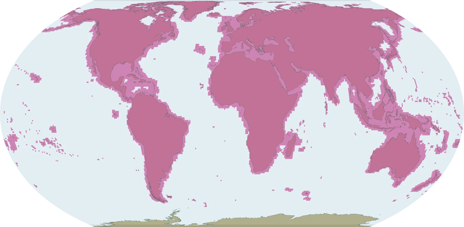
For 2023, 2024 and 2025, the archive covers land and adjacent coastal waters from 59.5°S to 83.6°N, excluding Antarctica; 2017–2022 cover selected countries. The dataset documentation’s coverage illustration shows the expected footprint once all years are complete, rather than availability for every year. Its block-based coastal outlines can include water without embeddings. Annual periods limit how precisely a comparison can locate a change in time. The technical report describes the colored embedding display as a simplified visualization. Our reading is that similarity is a starting point for investigation; conditions on the ground still need supporting evidence.
Custom dates bring back the setup work
Ai2’s linked implementation tutorial describes a more involved route for a particular location and time window: define the area, download and align satellite images, then compute and save embeddings. It recommends a year where practical, while allowing shorter windows for features that change faster.
That route has costs and prerequisites beyond obtaining model weights. The example uses Sentinel-1 and Sentinel-2; adding Landsat through its documented route requires AWS credentials for a requester-pays bucket, where the requester bears access charges. It also still names OLMOEARTH_V1_BASE in the model configuration. It documents the general workflow, but the configuration needs updating for this release. We have not run or adapted the example.
The main repository provides an inference-only installation option and recommends Python 3.12. It separately documents training and evaluation. That separation gives developers a route to load a model without installing every training dependency, but it does not remove the work of acquiring suitable imagery and preparing a specific task.
Access comes with consequential use restrictions
The model card offers downloadable weights and directs hosted-platform users toward partner access. It also says no Hugging Face Inference Provider currently deploys this model. The downloadable model and the hosted service therefore have separate access paths; the public release does not establish a managed endpoint for every user.
The OlmoEarth Artifact License grants use, modification and distribution without a license charge, subject to its conditions. It prohibits military and defense applications, including intelligence gathering, human surveillance and policing. It also bars uses that plan or facilitate extraction of resources, including oil, gas, minerals and deforestation.
Redistribution requires attribution to Ai2; distributing artifacts requires providing or linking the license, and downstream derivatives must retain its use restrictions unless Ai2 agrees otherwise. The permission to download is consequently broader than permission to deploy in every industry. For teams evaluating the release, the intended application is an eligibility question alongside geographic coverage and the time period their map must represent. The coverage illustration accompanying this report is reproduced from Ai2’s dataset documentation under its linked OlmoEarth Artifact License, with proportional resizing and format conversion only.
Sources & method
AI-assisted reporting from Ai2’s announcement, technical report, model card, repositories and artifact license, with original analysis. We have not tested the Explorer, generated maps or independently verified model performance.
- Ai2: OlmoEarth v1.3 — State-of-the-art embeddings for the whole planetPublished October 22, 2026
- Ai2: OlmoEarth v1.3 technical reportAccessed October 23, 2026
- Ai2: OlmoEarth-v1_3-Base model cardAccessed October 23, 2026
- Ai2: OlmoEarth training and inference repositoryAccessed October 23, 2026
- Ai2: Computing Embeddings using OlmoEarthAccessed October 23, 2026
- Ai2: OlmoEarth Artifact LicenseAccessed October 23, 2026
- Ai2/OlmoEarth: annual embeddings dataset and expected coverage mapAccessed October 23, 2026
- OlmoEarth dataset: accompanying Artifact LicenseAccessed October 23, 2026
Source pages reviewed October 23, 2026. Analysis and suggested evaluation methods are AI Toolcast’s own.
This article contains no sponsored placement or affiliate links.
Found a possible error? How to report a correction.
Keep reading
IBM expands Granite Speech with multilingual Turbo CTC and a new 2B model
IBM's October update adds Speech 5.0 2B, makes Turbo CTC multilingual and revises Plus. Language coverage, speaker labels and audio-processing limits differ across the downloadable models.
Inception releases Mercury 3 with a larger context and changed reasoning default
Mercury 3 expands text capacity and changes default reasoning effort as Inception winds down older models for eligible existing users. The migration brings access deadlines as well as API and pricing changes.
Mistral releases Timestral forecasting models for CPUs and GPUs
Mistral's Timestral models forecast numerical histories locally, including uncertainty and related inputs. CPU support lowers the hardware entry point, while the weights carry separate revenue-based license restrictions.